Planner's Comments
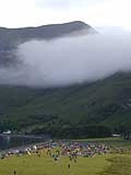
This year the area divided into three main mountain groups, these being the Arrochar Alps, the Ben Lui hills and Beinn Bhuidhe, with a lot of rather uninteresting but quite high ground between them. I wanted each course to be able to run through at least one of these groups each day so that all courses had the experience of being in the “bigger” hills. In linking up these groups there was always going to be some less inspiring running, but that couldn’t be avoided. In order to allow maximum use of the hill groups, the campsite had to be in the centre or north of the area (given that the finish was already arranged in Glen Fyne) since a campsite in, eg, the Arrochar Alps would make it hard for courses to cover the whole map. A few possible sites were discussed including the head of Glen Shira, and on a February visit with snow on the ground, Martin came back with word that it was possible. When I later visited it I had doubts as it looked a boggy, tussocky mess, but we decided to go for it hoping it would dry out a lot by June ….which luckily it did, to make a memorable campsite. We hoped that people would just spread out and find places to camp, which is what happened.
The Arrochar Alps are the most interesting part of the map, but it was too far for the D class to get from there to the midcamp, so the D were bussed to the northern side of the area and started with the Ben Lui hills. This gave the opportunity for the D to bag a munro, which seemed to be appreciated, before the trudge to the campsite. The other courses could all start in the south, though C had to head reasonably directly to the camp to keep the correct distance, however by starting C on top of the Rest and Be Thankful they were already 270m up (which they probably didn’t appreciate when faced with another 500m initial climb!).
Due to the nature of the Arrochar Alps, most courses had a fair amount of route choice on Day 1 and people tried everything going! It is worth noting that the planner’s route is very subjective as it is a route that suits the planner’s strengths so might not suit other runners. A classic example is the 4th leg of the Elite on Day 1, where the Symond brothers went straight up and over the shoulder of Ben Vane and across the Loch Sloy dam; other teams went south, a lot further but a lot less climb and a lot more tracks; also some went to the northern end of Loch Sloy. The planners route was the runnable route to the south (which the second placed Elite team did), but if you were a very strong climber then a direct route might be better but it wouldn’t be for everybody. You also need to consider whether extra climbing at that stage might tire you later.
The people who did best on Day 1 Score were those who weren’t tempted by the big points at the southern end of the map, but headed to the middle area so they were nearer to the campsite, when time started running low. Many people in the Score didn’t realise how long it would take to get to the campsite so racked up big penalties.
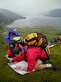
Generally people seemed to enjoy the first day, perhaps because the weather was so good, but a Mountain Marathon is a game of two halves, as they say, and the second day dawned dull, cloudy and drizzly. A lot of people would have already guessed where they going on day 2, as for B, C and D it was fairly obvious – over Beinn Bhuidhe in some way to get back to Glen Fyne. Even in the Score, most people would have worked out options over Beinn Bhuidhe and that is what they did, with easterly routes being very much in the minority. For all linear classes, major route choices were more limited on the second day than the first day, due to the nature of the terrain, but there was plenty of more minor variants on the legs and these could be vital (even more vital as it turned out due to the low cloud). C and D bagged another munro, while most B runners went fairly close to the top (not sure if any made the extra diversion to bag it!). The Elite class could be long enough to get to the Ben Lui hills and back to Glen Fyne (just), though it meant having a route with a fair bit of fast running to get out and back, but the Elite should expect that, and it made a contrast to the big climbs of the first day. The low cloud also made some controls hard to find and meant being in touch with the map was vital.
Every event has one class that isn’t easy to plan due to the positions of the Event centre and mid camp – unlike the first day, both start and finish are fixed. Often it’s the D, which is forced to go in a straight line to get back in reasonable distance. This year it was the A class. It was hard to fit in a decent A. It would either be too long (and too boring), if heading east, or a struggle to fit in a course on Beinn Bhuidhe. In the end A did a circuit of Beinn Bhuidhe, but, and also because of the mist, it turned out to be too long. In retrospective, the last couple of controls should have been omitted.
I hope people enjoyed the event. With the change in conditions over the two days it really tested different aspects of Mountain Marathoning … hot and sunny and great views one day, cold and misty the next; macro route choices on day 1 and close navigation on day 2. Winning times were about right for all classes except, as I mentioned, for A.
Thanks to everyone who helped put out and collect controls; to the controllers, Brian Jackson and Dave Coustick for their invaluable advice and to organiser Martin Stone, who was always happy to arrange buses to wherever I asked, despite the logistic nightmare.
Andy Spenceley