|
PLANNER'S
REPORT
We had initial
plans for the LAMM in this area, with an event centre at Inverlael,
even before the 2010 LAMM at Arrochar as Martin had already made
some contacts in the area, but decided it was better to wait a year
to give more time to more time to plan and organise as it was a
long way north and a remote area.
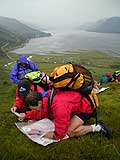
So it was a
rainy day of low clouds last September when I walked across the
hills to Strath Mulzie to have a look at a proposed mid camp. Even
the very large adder that I nearly stepped on, near where the toilet
trench ended up, was trying to get out the drizzle. It didn't look
the most inspiring place in those conditions, but there was plenty
of flat grassy land to camp, a lovely river (that I tried to imagine
campers sitting beside in the sun!) and I knew that up in the mist
was Seana Bhraigh and reckoned we'd get a good view of it from the
campsite in good conditions. We'd considered various other options
for the mid camp but this one fitted in best with distance to event
centre and central enough on the map to allow access to most of
the area for the courses.
Once we had
the event centre and mid camp fixed I could get on with planning
the courses. I wanted all courses to be able to get right on the
tops as people travel a long way to do the LAMM and if you come
form the south of England, Sweden or Spain you don't want to go
home having spent the weekend at the bottom of valleys! One of the
good things about the area that helped this was that once you got
up high in the central area you could stay fairly high and the going
was often very fast. Between Beinn Dearg and Seana Bhraigh the ground
is above 700m all the time and don't go much lower round the northern
side of Gleann Beag to Carn Ban and Bodach Mor. There was an area
of dangerous crags and slabs along the eastern slopes of Beinn Dearg
and Cona' Mheall most of which weren't mapped so I decided to avoid
this area as much as possible.
I decided to
sent the C and D courses over the Munros on the first day as, particularly
for the D, it was too far to have reasonable routes over them on
the second day. D also had to start from the event centre on day
1 as anywhere else would make the day too long. I could then send
these courses over the lower ground to the north west on the second
day so they had a lot less climbing, but to make up for that the
control sites were more generally more challenging so you had to
keep a close eye on the map. Both courses had two main climbs on
day 1, both up (or near) a Munro summit. C had reasonable route
choice on the first day, but D probably had less as the day was
more about enjoying the high ground once you were up.
The B is long
enough that I could use the high ground on both days, but I didn't
want to overlap the area covered, so after an initial climb up Beinn
Dearg (I hope they forgave me for that!) the course on day 1 headed
north eastwards towards Carn Ban and then approached the mid camp
from the east. Again there were 2 major climbs. This meant on day
2, the course could go over Seana Bhraigh and the high ground to
the south giving two more Munros. I think there was quite a lot
of route choice on this day and on one leg in particular I was amazed
at some of the routes! I don't know if it was just tiredness but
a lot of people seemed to make the last long leg from Eilidh nan
Clach-Geala (106) to the spur (138) very hard by dropping too low
- even right down into the forest for some teams! Here's a clue
- if there are waterfalls shown on a map there is usually a ravine
or steep ground below them, so best to cross above.
The A and the
Elite both kept to the eastern half of the map on the first day
so they could cover the central ground the second day. They both
crossed Am Faochagach (with an option to bag the summit, if they
wanted!) from different directions and ended up on Carn Ban/Bodach
Mor. The Elite did have some rough going on a big loop east of Loch
Vaich and a tough climb back across Gleann Mor, which some complained
about, but I ignore those complaints from the Elite! After some
comments from Elite and A competitors in previous years, I made
sure they reached a few summits this year, mainly on the second
day when they crossed the central Munros and had options of good
ridge climbs.
The Score is
always hard to plan as it attracts people from Elite standard to
C (or even D ) standard and these are not realistically competing
against each other. For the C/D people I had to make sure they could
get to the mid camp in the 7 hours and home in 6 hours while having
a good day out and picking up a few controls on the way and give
them a chance to do a Munro or two. On day 1 I think most people
reached the summit of Seana Bhraigh. The top Score people can cover
a long way in 7 hours, so on day 1 they had the option of doing
a similar course to the Elite day 1 (as the 5th place Score team
did) or options on a loop from Am Faochagach, Beinn Dearg and round
the north side of Gleann Beag before heading to the mid camp, as
the leaders did. Because the controls cover such a large area in
the Score class there is always a bit of an overlap over the two
days. My planned "elite" Score route on day 2 was exactly
what the leaders did (see RouteGadget), with the other main option
to go west from the start and then head back east.
Most of the
winning times were about right this year, perhaps slightly on the
fast side, but if the weather hadn't been as good times could have
been considerably longer.
Thanks to everyone
who helped me, particularly Brian Jackson, Dave Coustick, Angela
Mudge, for comments and advice on the courses and also for help
marking and putting out controls. Also thanks to organiser, Martin
Stone, for always being very supportive and always being open to
ideas.
Andy Spenceley
|