|
Planner's Report
Andy Spenceley
Being asked to plan the LAMM is a privilege (that's how Martin made it sound when he asked me - if I'd known then how much work it would be I might have had second thoughts!). It is a chance to influence the event and to use your ideas of what you think a mountain marathon is about. For me, that is not just an extra long orienteering event, but more than that, it is all about a journey through the mountains. A journey where you have to make route choice decisions, climb some mountains and see some great places and finally get great satisfaction in having completed something hard.
To give route choices, I had relatively few controls and some longish legs, particularly through the highest mountains (for A, B, C and Elite on day 1). I was amazed at the variety of routes taken. People tried virtually every one I thought possible and more! I wanted to put more emphasis on teams having to make route choice decisions rather than fine orienteering in finding controls, although several of the controls were quite hard and the mist did make finding even relatively easy controls harder.
Each course had the opportunity to climb a mountain (and for A, B, C and Elite, this included a Munro or two). Some were forced to by a control on the top (eg D and N on Glas Bheinn on day 2), others had the option in route choice. A Mountain Marathon is not really a Mountain Marathon if you don't get to the tops. So if you were wondering why you had the long slog up Beinn Leoid on day 1 of the A class, it was (to reuse a famous quote) "because it was there" (and you go home feeling you have achieved something).
As for views and places of interest, unfortunately many of the views I'd hoped you'd see were lost in the mist! But natural features in the area that many of you saw included the famous bone caves; Britain's highest waterfall (over 200m drop) and the Stac of Glen Coul (which, for geologists is very important as is arguably the finest exposure of the Moine thrust, which led to the theory of Teutonic plates - but the view was good as well!).
I spent several enjoyable weekends in the area wandering all over, camping in the middle, checking potential control sites and terrain. By the time of the event, I felt I knew every boulder field and peat hag in the area and realised it was a great venue. Once it was an option, I was very keen for the campsite to be at Glen Coul as it was so special, however, the positions of the campsite and event centre on the map made planning quite hard for the longer courses. Basically it meant that the Elite and A (and B slightly) ended up crossing some of the same ground on day 2 as on day 1. It also meant that I couldn't get as far north as I'd wanted, as it would then be too far back to the event centre.
By starting the D and Novice in the north at Kylesku on day 1, they were in a completely different area on each day. I couldn't do that with the other courses or they'd never have got to Ben More Assynt and Conival. You wouldn't have wanted to miss that, would you?. D was about right on both days but Novice was perhaps slightly harder than normal on day 1 due to there being no obvious "handrail", eg a valley to follow, to get to the campsite. Also, it was a steep descent to get to the campsite whichever way you went. I took the Novice the shortest way, which may have been a mistake as the bottom section was perhaps too steep (the A also came down that way). Apologies if you found it intimidating.
The C course on day 1 had a couple of interesting legs, one being the leg over/round Conival. Lots of imaginative route choice here, the whole mountain must have been swarming with runners! On day 2 the C course was probably the toughest per kilometre due to the fact it stayed high (after taking the shortest route out of Glen Coul!), running the length of the ridge to the north of Inchnadamph, a lot of which was rough going and all was in mist. Due to the mist it was impossible to spot the grassy routes between the boulder fields, making it very slow underfoot, so the times on the C were the most affected by the mist as the other longer courses all had sections of easier (if peaty) moorland running below the cloud. If you finished the C in those conditions, have a pat on the back!
On the B, the very long leg 2 on day 1 was worth spending some time thinking over. My feeling was the route was dictated by finding the control and the north ridge of Ben More Assynt led down directly to it. Heading east from control 1, dropping to the river Oykel and then using the stalkers track up the glen (marked on 1:25000 only) and crossing Ben More Assynt was probably the best bet. I was amazed that quite a number of teams took the very long track option to the east. I had thought it was too far to be a serious option, however people who went this way claim they didn't lose time on those going over the hills. I think the weather resulted in some teams being tempted to stay low and go this way (and you can't go as fast over the hills in the mist). On a nice day, I don't think many would have taken the path...much too far, and makes finding the control harder from that approach.
The Elite and A both worked out fairly well. Times were about right. Day 1 of Elite could have been a bit longer but would have cut into terrain I wanted to save for day 2. Many teams on Elite went over Ben More Assynt and Conival on day 1, but the fastest split was when contouring (I still find hard to believe but blame the mist again!). I was surprised by how many A teams went over Ben More Assynt as had expected most to use the col between it and Conival, but it possibly made finding the control easier as you could then drop straight down to it. The second day of both classes had to be fairly long due to heading north but I knew there was a lot of runnable terrain so wasn't worried. On day 2, the first legs of both Elite and A were interesting and the fastest split was on the long way round the peninsular over to Loch Glendhu, which very few did.
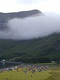
Best memories? Lots! A lucky dozen or so of you (myself and Angela Mudge included) saw an otter swimming around in the bay at the campsite, at about 10.30pm, when all was quiet and most were asleep; sitting on top of the Stac of Glen Coul watching the tired C and B teams climb up to the spectacular and airy viewpoint and then hearing all the positive comments; the days wandering and camping in the area in hot sunny (yes, true!) weather never meeting another person; the fantastic, sociable campsite (for first timers more used to hiding in your tent at a MM, this is a feature of the LAMM with its light evenings).
Special thanks to the controller Angela Mudge, who was great at coming up with suggestions and doesn't beat about the bush when telling you your control site is rubbish! She was a great mentor and source of advice for a rooky planner and I bounced ideas off her all the time. Also thanks to Dave Coustick (who was there all week) and Adam Ward who helped the week before to put out controls. We couldn't have managed this without them. Hilary Spenceley, who put up with many, many late nights as I juggled controls and courses (you end up dreaming course doing this!) and finally to all those who collected controls, which allowed me to leave on the Sunday, and to Martin for letting me loose with the map!
|